
Feb. 18-19 Post Storm Analysis
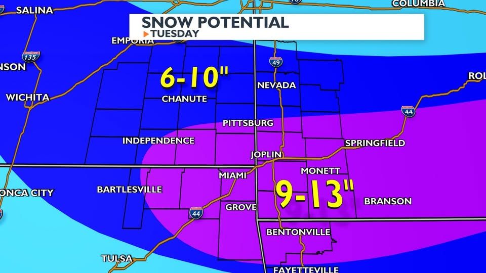
On February 18th through February 19th, a winter storm impacted Southwest Missouri, Northwest Arkansas, and Northeast Oklahoma. Forecasted amounts outside of WoolawayWx put in final forecast around the 12-16" mark for most of Southwest Missouri. Below are some examples from across the area, all sourced from public post on Facebook and/or X. Times and links to the post will are available under each image.
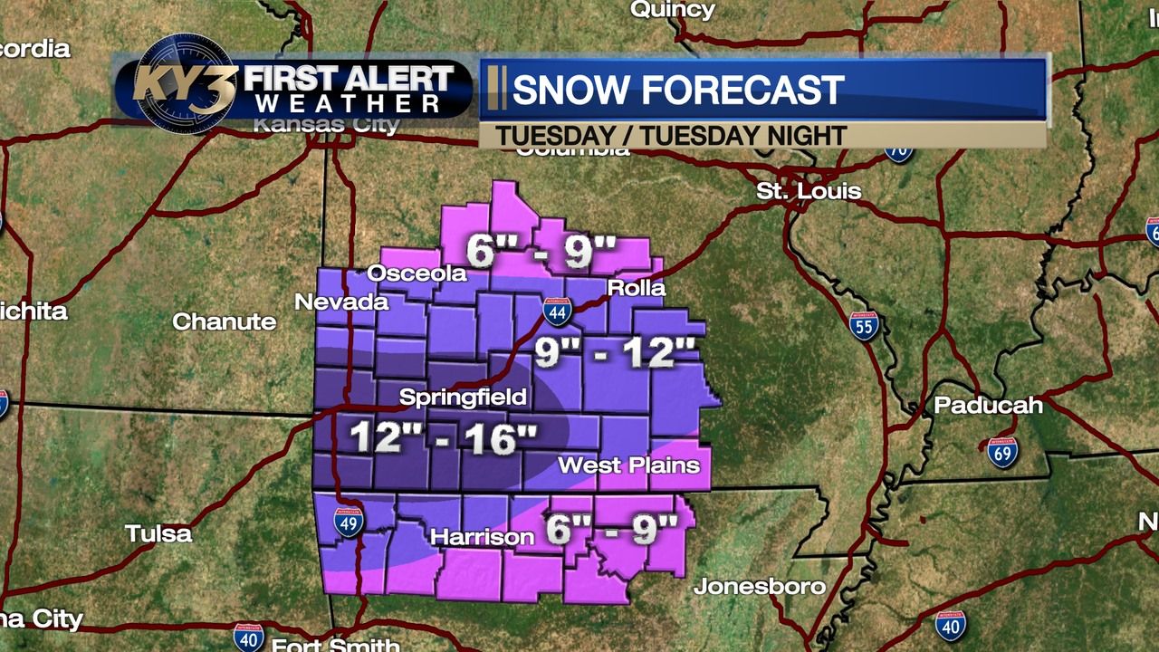
Ky3 Weather - 02.17.2025 at 8:31 PM - https://www.facebook.com/share/p/18r24poAik/
KOAM / Doug Heady - 02.18.2025 at 10:41 AM - https://www.facebook.com/share/p/15huivJXca/
Channel 12 Joplin / Ray Forman - 02.17.2025 4:17 PM - https://www.facebook.com/share/15gkXbfR8R/
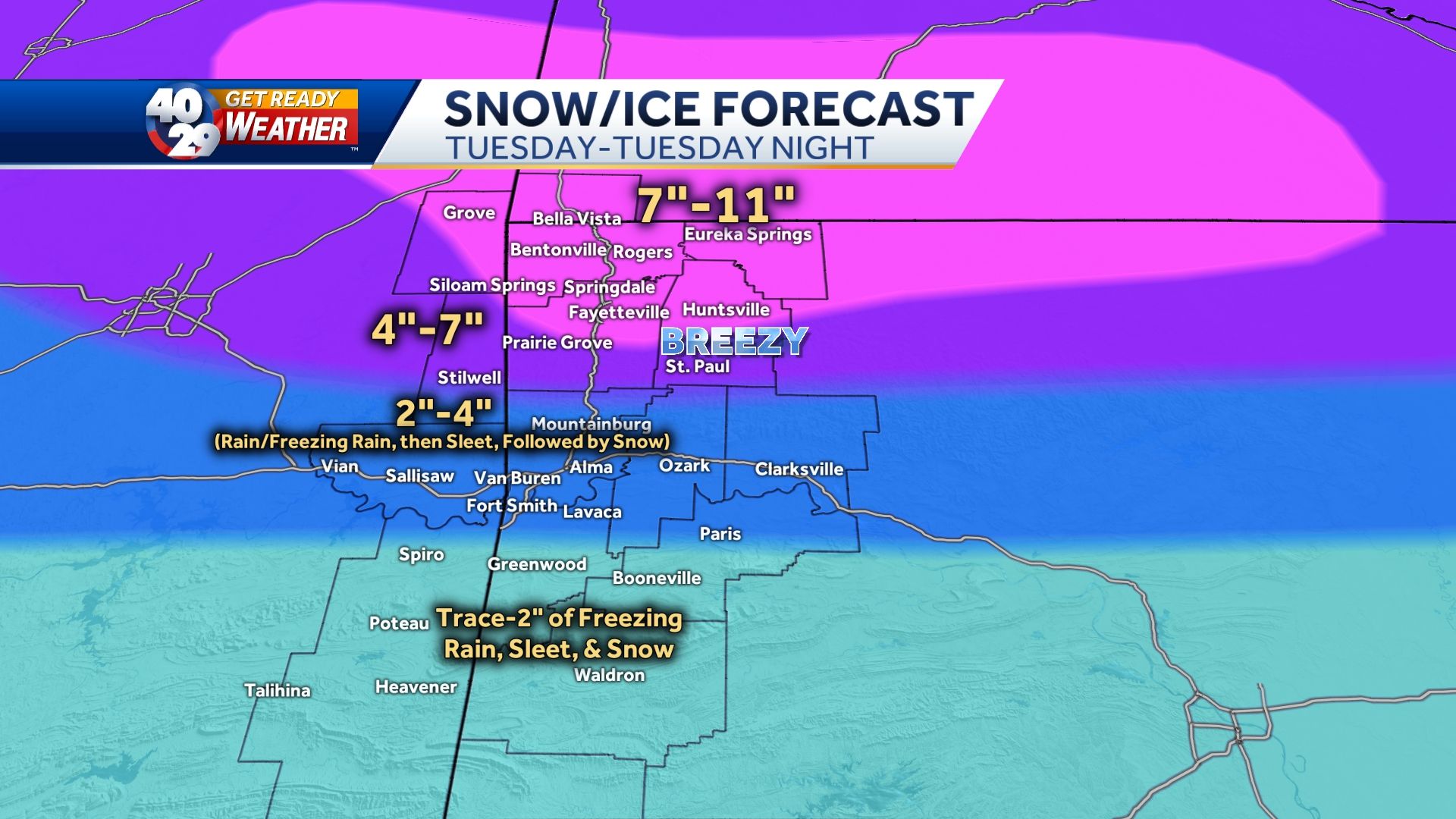
40/29 News - 02.18.2025 4:18 PM - https://www.facebook.com/share/p/1YJaFaXSwn/
And lastly, is my own final forecast that was put out around 5:30 PM on 2/17.
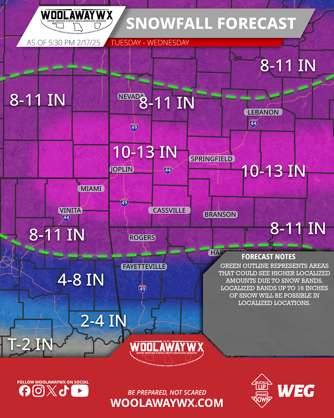
WoolawayWx - 02.17.2025 5:30 PM - https://www.facebook.com/share/p/1UyQHkwykH/
The Breakdown
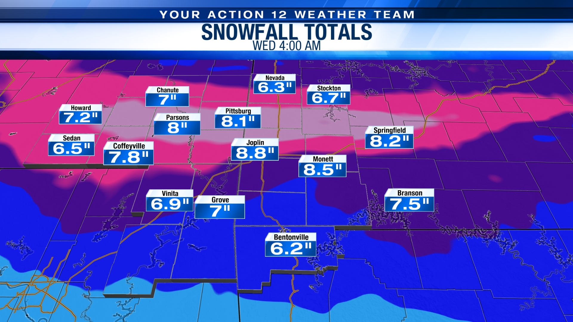
So as you can tell by the graphics above, there was a lot of variation in forecast, but every forecast (including mine) was wrong. Here are the LSR's from NWS Springfield, Tulsa, and Little Rock starting at 2.19.2025 1 AM till 2.20.2025 10 AM. The timeline starts at 1 AM on Wednesday to clear out reports that came in while the event was still occuring.
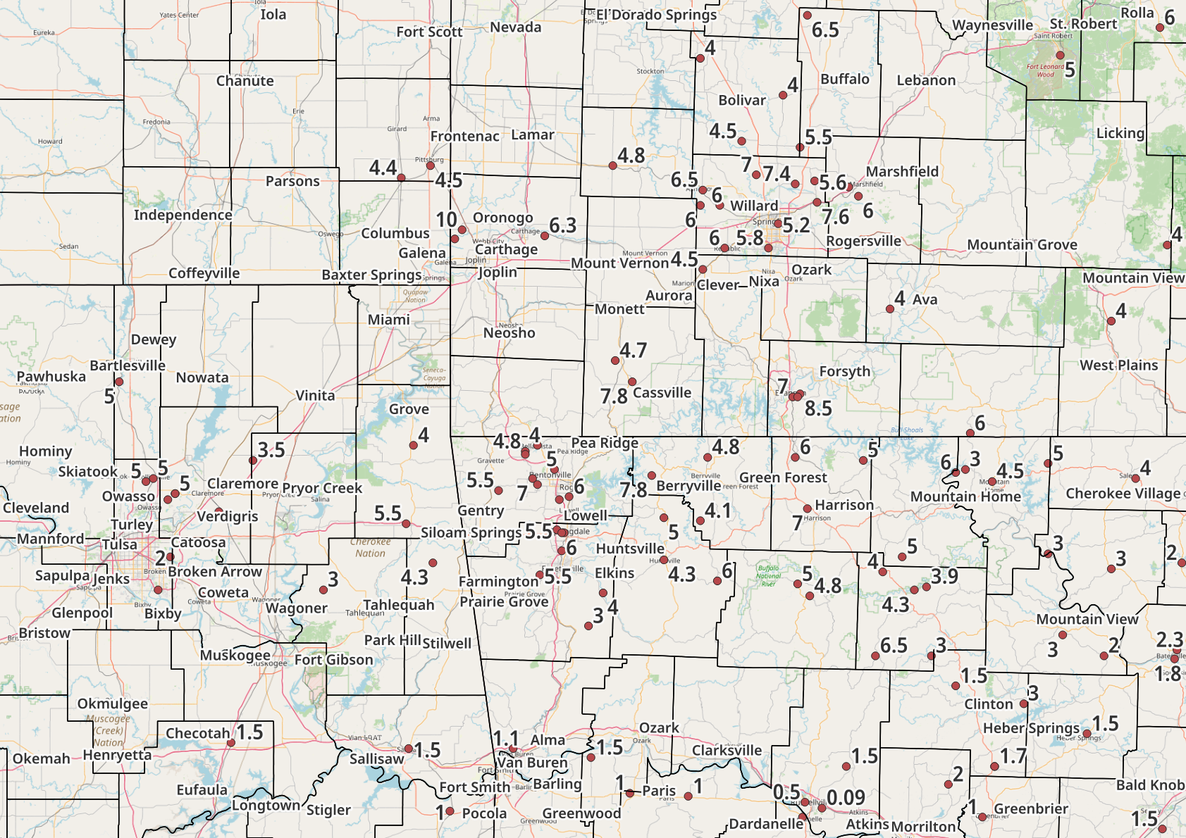
As you can see there is quite a variation in amounts, especially in Northwest Arkansas. However, those variations still don't match what what forecast were saying.
So why...
Snowfall is generally based on the ratio of how many inches of snow accumulate per inch of liquid precipitation, commonly referred to as the snow ratio. Most of the time, we see ratios ranging from 9:1 to 12:1, where 9:1 represents a heavier, wetter snow, and 12:1 corresponds to a lighter, powdery snowfall. Given the characteristics of the snow that fell during this event, which was very light and powdery, it aligns with reported snow ratios of 11:1 to 13:1 across the area.
One of the main reasons snowfall totals ended up lower than forecasted was the overestimation of the snow ratio in many forecasts—including mine. My forecast was based on a 13:1 to 14:1 ratio, while some other projections, which predicted even higher totals, used an estimated 14:1 to 16:1 range. While a difference of just a couple of points in the snow ratio may seem small, it actually has a significant impact on total accumulation. This discrepancy can be seen in the graphics provided by various outlets across the region, showing how snowfall amounts trended lower than initial projections due to these lower-than-expected ratios.
Another important factor to consider is the difficulty in accurately measuring this kind of dry, powdery snow. However, I want to emphasize that measurement challenges alone are not the reason forecasts missed the mark. Some weather pages may point to this as an excuse, but the primary reason most forecasts were off by 2-3 inches was due to incorrect assumptions about the snow ratio. I take full responsibility for this miscalculation in my own forecast.
While strong winds and snow drifting complicated measurements further, we expected high winds throughout the event. The environmental setup leading into the storm made it clear that this was going to be a dry snow event, meaning that verification of snowfall amounts would be difficult. Even with this in mind, we can now look back and acknowledge that snowfall totals underperformed compared to forecasted amounts.
How to be Better?
Winter weather is the type of weather I dislike the most, not necessarily because of the conditions themselves, but because it doesn’t take much for a forecast to shift drastically. One small change in the setup can completely alter the outcome, making winter forecasting one of the most challenging aspects of meteorology.
That being said, people need reliable information to prepare for whatever is coming. They need someone they can trust, not just to provide the best forecast possible but also to take accountability when things don’t go as predicted. I believe that’s just as important as getting the forecast right.
For myself, one of the biggest takeaways from this event is to trust my own analysis more and avoid being overly influenced by social media forecasts. When I was increasing snowfall totals in my last forecast, I was hesitant. It didn’t feel right. But over the previous 48 hours, I saw other pages and forecasters putting out higher amounts, exceeding what I thought was reasonable. That made me feel like I was in the right range, that I wasn’t being too aggressive with my forecast.
Now, 48 hours later, I regret that call. Looking back at the data, I can see where adjustments could have been made, and I’m already focusing on how to improve for the next event. Every missed forecast is an opportunity to learn, and that’s exactly what I intend to do.
I truly appreciate everyone who trusts WoolawayWx to provide accurate and dependable weather information. My goal is always to give you the best possible forecast so you can prepare for whatever may be heading toward Southwest Missouri, Northwest Arkansas, and Northeast Oklahoma. No matter what the weather brings, I will continue working hard to ensure you have the information you need.
Thank you for your continued trust and support!
-Cade